Highlights
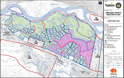
- The final buildout of the Dredge Pond II Subdivision is 40 country residential lots which equates to approximately 88 people.
- The Dredge Pond II is intended to incorporate extant natural areas and to respond to natural features.
- The development concept is based on a development pattern comparable to the adjacent Dredge Pond Subdivision and other existing developments along the Klondike River valley.
- The layout and design of the lots complies with municipal and environmental regulations including minimum zoning setbacks and Environmental Health setbacks. Standard single detached dwellings with or without a garden suite can be built on the lots.
- Dredge Pond II covers an area of 143 hectares (353 acres). A little less than one-third of the area is devoted to housing. The 40 residential lots are divided into three residential clusters. These clusters provide infrastructure, services, and cost advantages.
- Roads would be either gravel or BST. All lots would be serviced with overhead power. Lot owners would be responsible for installing private water and sanitary servicing.
- Roughly 50% of the total developable area is reserved as open space for recreation, habitat, and flood protection. In addition, less than a quarter of the land is designated for heritage use and protection of dredge tailings, cultural landscape, and heritage resources. Much of this area cannot be developed as residential lots as they are either adjacent to the river, are low-lying, or have geotechnical constraints.
- The Master Plan includes a central playground, walkways that facilitate non-motorized trail use in the neighbourhood, and a historic park that safeguards one of the last remaining sections of dredge tailings within the municipal boundary.